
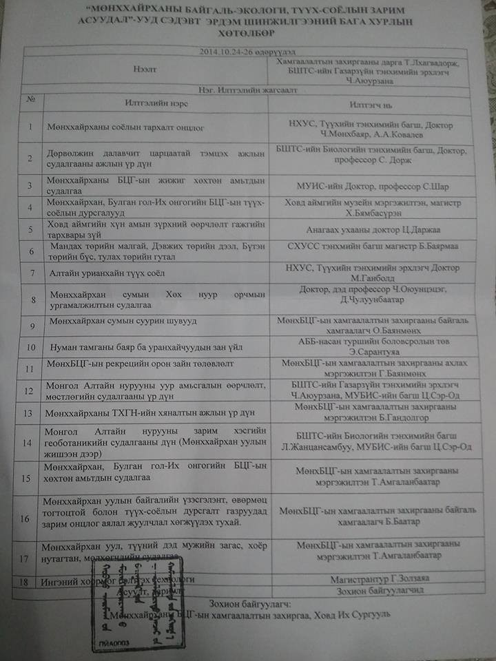
Монгол Алтайн нурууны уур амьсгалын өөрчлөлт, мөстлөгийн судалгааны үр дүн
Илтгэсэн хурлын нэр: Мөнххайрханы байгаль-экологи, түүх соёлын зарим асуудал сэдэвт эрдэм шинжилгээний бага хурал
Илтгэгч: Ц.Сэр-Од
Хамтран илтгэгч:
Илтгэсэн огноо: 2014-10-24
Илтгэлийн хураангуй: In august 2013 Saint-Petersburg State
University together with Khovd University carried out the reconnaissance investigations
in the Tavan Bogd region and surrounding area. The main goal of the expedition
was to choose the representative glaciological basins for further several
years’ monitoring of the mass balance, glacio- and hydro-climatological
relations, cryogenic forms, to expand sparse dendrochronological net and to
make some primary measurements.
Currently the most underinvestigated and difficult to access Kozlov
glacier in the Tsagaan-Us basin and Potanin-Alexandra glaciological complex in
the Tsagaan Gol basin were chosen as a representative. We made visual estimation of the accumulation and ablation zones of the Kozlov,
Alexandra, Grane and Krylov glaciers and several rock glaciers. For the future accurate
measurements of open glacier and rock glacier dynamics the geodetic survey of
their tongue edge using Trimble GNSS surveying system and GPS survey of firn line
were conducted. In the accumulation zone several snow pits were made for the
snow-firn layer structure estimation. Another important goal was to conduct field
classification survey using SPOT-2 satellite data and topographical maps (1:100
000). Several loggers were placed to estimate annual temperature regime of the near-glacier
air temperature and glacier ice temperature. Occasionally during the expedition
we collected the dendrochronological data using basic dendrochronological
techniques: sample cores from 86 living trees of larch (Larix sibirica) from 6
sites on the upper (2400–2500 m) and lower tree lines (2000–2100 m) on the
north-facing slopes. The sites are characterized by sparse growth of trees and are located in
Khovd and Mogoityn river basins, and near the Hoton Nur Lake. We are measuring the tree-ring width using Lintab 6 system with accuracy
of 0,01 mm and are planning to estimate the natural factors which influence on
tree-ring growth, make reconstructions of the climatic characteristics using
meteorological data from the regional weather stations, and also make
dendroglaciological and dendrohydrological analysis. In addition we collected some fire-scarred cross sections from
fire-prone landscapes to reconstruct the fire history of the region. In the near future we expect to estimate the modern morphometric
parameters of the glaciers and rock glaciers, dynamics during the last several
decades using aerial photograph, space images, topographic maps and field data,
to create space image interpretation standards, updated glacier catalogue, to make
statistical analysis of the meteorological data from the reference weather
stations as an important activities before the monitoring research.